
São Miguel
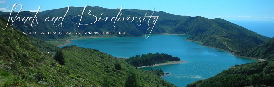
São Miguel is the second easternmost island in the archipelago, after Santa Maria, and is the largest of the two (757 km2). It is also the capital of the archipelago. Geologically it was formed in six volcanic stages, including the northeast complex (the oldest zone) and Picos, of more recent volcanism. These different formations are reflected in the landscape and geomorphology, so that the oldest sectors reveal considerable gullying, with rugged valleys and ravines that have undergone centuries of heavy erosion, a fine example being Serra da Tronqueira, in the eastern section. The highest point, Pico da Vara (1103 m), is located in the same area. Conversely, the Picos region offers a practically flat landscape and an important chain of volcanoes or cinder cones, alongside lava flows that run towards the sea. Prominent geomorphological features include lake-filled craters or calderas, some of which are quite large, such as the twin lakes of Sete Cidades, Furnas and Fogo. The coastline is made up of cliffs of varying heights, which are sometimes sheer rock faces of 200 m or more, and undulating low-lying platforms that were formed from lava flows pouring towards the sea or perhaps the occasional landslide. These platforms are known locally as fajãs or plains and there are fine examples at Mosteiros, Ponta da Ferraria and Maia. Black or grey sand beaches, mostly basaltic in origin, are dotted around the coast, and Ribeira Grande on the north coast boasts one of the largest.
The most salient feature of the climate is high rainfall, which is true of the archipelago in general and evident on São Miguel. However, since precipitation increases from east to west, islands like Flores are much wetter. Average annual rainfall in Ponta Delgada, the capital is around 1000 mm, and in more mountainous regions it is most likely two or three times higher. An important difference between the two eastern islands and the others is the influence of the northeast trade winds, and the considerably higher sun index.
São Miguel has a population of 137 700 (2011) and was one of the first two islands in the Azores to be colonized after its discovery in 1427 by Diogo de Silves, under the auspices of Prince Henry the Navigator. Before human settlement, many heads of cattle were introduced to provide supplies for the future settlers, a common occurrence throughout Macaronesia. The early settlers originated mainly from the Alentejo region of Portugal, Extremadura (Spain) and Madeira.
The local economy is still largely based on the primary sector, especially stockbreeding, which is closely associated with exports, since a high percentage of dairy products in Portugal are imported from the Azores. This explains the extensive pasturelands found all over the island. Agriculture played a vital role almost immediately after colonization, with the introduction of cereals (wheat, millet, etc.) and subsequently sugar cane. In more modern times, new crops include oranges, pineapples, tobacco and tea. Fishing, mainly tuna, is important, although whaling was once a leading activity until it was banned. However, whale and dolphin watching from land and sea (aboard authorized vessels) is now a significant part of sustainable tourism. In recent decades, the rise of tourism throughout the archipelago has been considerable. And this is also true for São Miguel, whose many attractions, not least because it is the capital island, include beautifully preserved traditional dwellings and magnificent tropical gardens.