Boavista Island
Of all the Cape Verde islands, Boavista is the closest to Africa, at just 567 km distance. It is also one of the Barlovento or Windwards Islands (along with Sal and Maio). It has a surface area of 620 km2 and rises to 390 m at its highest point, Monte Estância. Sal Rei is the capital and is located in the northwest sector, overlooking the small islet of Ilhéu do Sal Rei, 1.8 km long and 0.7 cm wide. The coastline is very flat, with numerous sand dunes and golden beaches of organogenous sands.
There are also broad stretches of stony flatlands, and a few hills and peaks, such as Monte Estância, Rocha Estância, Povoação Velha and Monte de Santo António, are dotted over the landscape. The only coastal cliffs of some size are found between Praia da Fátima and Ponta do Sol, and near Morro Negro. However, they are not sheer and the base is a platform of lava flows or debris. The longest sandy beaches are those of Curralinho (13 km) and Santa Mónica (11 km), on the south coast, and Costa de Boa Esperança, in the north. Boavista has a dry sunny climate and average annual rainfall does not exceed 275 mm; some years it does not rain at all. In contrast, with the arrival of monsoon-like rains, the landscape is utterly transformed for a few weeks and the ravines run with water. Spots that have a permanent supply of fresh or brackish water are Ribeira de Água or Laguna de Rabil, and Olinho do Mar, located in the mountainous region in the east.
The population of Boavista is 9162 inhabitants (2010 census) and has more than doubled since 2000. In fact, Boavista and Sal have sustained the largest growth in population in Cape Verde in recent decades. It is no coincidence that tourism is developing rapidly on both islands, making then a powerful magnet for people from other parts of the archipelago, from the African continent, and to a lesser extent from other latitudes. Consequently, the economy of Boavista is undergoing a rapid transformation, moving away from the primary (agriculture, stockbreeding and fishing) towards the tertiary sector (services and tourism) in just two decades, although agriculture, mostly dry farming, fishing and to a lesser extent stockbreeding are still practised. The rise of tourism has led to the introduction of diving and deep-sea fishing, as well as other water and outdoor sports, which is diversifying the local economy.
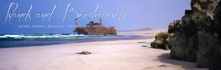
The history of the Boavista has been shaped by the food crises brought on by droughts, which is also true for the rest of Cape Verde. The ensuing death rate was high (particularly between the 18th and late 19th centuries) and resulted in emigration to other islands offering better living conditions, like Fogo and São Nicolau. Unusual economic activities of the past include exploiting calcareous sediments to obtain lime, obtaining clay for making pottery (Rabil ceramics are still renowned), gathering sea salt from the salt flats at Sal Rei and a small fish canning industry. By way of historical anecdote, in 1968 the Spanish merchant ship Cabo de Santa María ran aground on the Costa de Boa Esperança; its remains are still visible. Nowadays, major changes are taking place in the landscape and in traditional activities, as a direct result of new hotels in towns like Sal Rei, Praia das Chaves and to the west of Curral Velho. Moreover, a new international airport has been built and roads are gradually being improved. This panorama points to a clear rise in population and visiting tourist numbers.