
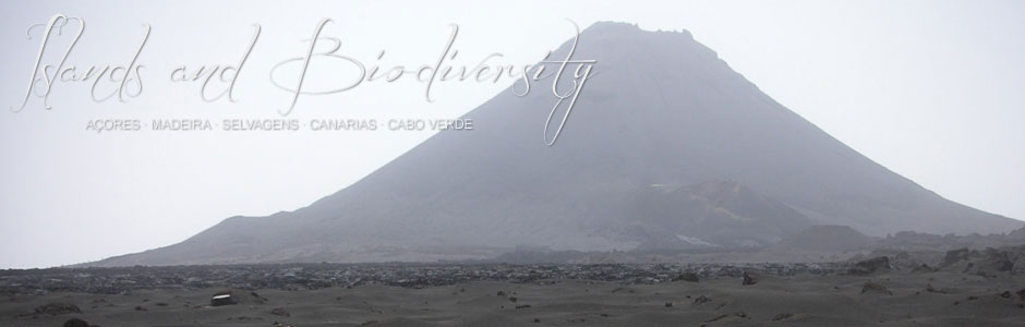
Fogo
Fogo (476 km2) is part of the group of Sotavento Islands, and its highest peak, Pico Novo (2829 m) is also the highest point in the archipelago of Cape Verde. The geography of Fogo has been greatly influenced by recent and historical volcanism—the last eruptions were in 1951 and 1995—and the landscape is dominated by tongues of lava that extend towards the sea. Apart from the stratovolcano of Pico Novo, the most outstanding geomorphological feature is the no less impressive caldera that surrounds the volcano on the western side, rising to 1000 m asl, at its highest point, and measuring 9 km from north to south. The eastern half of the caldera slid towards the sea as the result of a large gravitational landslide. The local climate is heavily influenced by monsoon-like rains, which usually arrive between August and October and cause a dramatic transformation of the landscape. However, fronts from the north can also bring rain in winter. The dampest zones are located on the northern flank, particularly near Monte Velha, where rainfall is relatively high.
Fogo has a population of 37 051 inhabitants (2010 census), who chiefly make a living from traditional activities, such as agriculture, stockbreeding and fishing, although the services sector is gradually on the rise. Tourism in Fogo is still limited, but firms specializing in eco-tourism (accommodation, hiking routes around the Bordeira or external wall of the caldera, ascents of Pico Novo, etc.) are gradually making an appearance. The capital of São Filipe is also of interest to visitors, particularly because of the magnificent traditional architecture of its old colonial balconied houses or Sobrados.
Fogo is known for its coffee, grown in the area above Pai António, where the damp climate is ideal, and wine, produced around Chã das Caldeiras. The island takes its name (fogo or fire) from the volcanic activity that has marked its history. Many inhabitants have often been forced to migrate to other islands in the archipelago (especially to Brava, the nearest), which was certainly the case in 1680. On that occasion, various lava flows poured down to the sea, destroying towns and villages en route. Fortunately, the eruption in April 1995 did not extend beyond the limits of the central caldera of Chã das Caldeiras and, though it did affect crops, it only damaged a few houses at Bangaeira and Portela, actually located inside the caldera. These are the highest villages in the archipelago and are inside Fogo Nature Park, created in 2003 by the government of Cape Verde.