
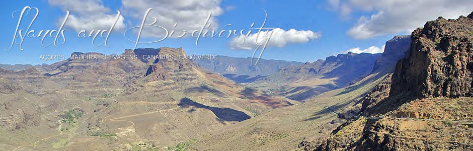
Gran Canaria
Gran Canaria (1.532 km2) is the third largest island in the archipelago of the Canaries and the capital of the province of Las Palmas de Gran Canaria. It rises to a maximum height of 1,940 m at Pico de las Nieves, although the central area of the island is dotted with other high points, in particular Roque Nublo (1,813 m), Roque Saucillo (1.709 m) and Roque Bentayga (1,412 m), all well-known geographical landmarks. It is rounded, extremely rugged and scored by deep ravines and valleys that diverge radially from the centre of the island. Coastal cliffs tower above 300 m in the west, but the eastern and southern shorelines are rather flat, as is part of the north. The most outstanding geomorphological features are the massifs of Tamadaba in the northwest, Inagua in the centre-west and Amurga, in the south, in addition to the vast erosive formations of Tirajana and Tejeda calderas in the centre. The Bandama and Los Marteles calderas are fine examples of recent volcanic edifices.
From an environmental and biogeographical perspective, the island is divided into three large units, namely the north flank, which faces the northeast trade winds; the ridge or the highest point in the centre of the island; and the dry, south-facing flank. These three units mostly coincide with the geological timeline. Two major aspects distinguish Gran Canaria from neighbouring Tenerife: the existence of important sand dunes and vast beaches of golden sands, particularly in Maspalomas (southern tip), and the absence of episodes of historical volcanism. In fact, the few recent and subrecent volcanoes in Gran Canaria are situated on the north flank.
The climate is Mediterranean-like, which is true of all the Canary Islands, and is heavily influenced by the rugged nature of the island. The peaks of the centre-north and surrounding area receive the highest annual average rainfall, which can exceed 1,000 mm, while the semiarid and desert-like areas in the south, east, west and north have fewer than 250 mm. The north flank is noticeably wet, due to the northeast trade winds, which cause the formation of a sea of clouds between 600 and 1,500 m for most of the year. By way of contrast, the south is exceedingly dry and temperatures are relatively high, occasionally exceeding 40º C, although the annual average for the whole island is around 20º C. The northeast trade winds are a constant feature throughout spring and summer, but the island is occasionally blasted by hot dust-laden air, known as harmattan.
The 2010 census registers the population of Gran Canaria as 845,676. More than half live in the capital, Las Palmas de Gran Canaria, which is the largest metropolitan centre in the Canaries. The second city, in terms of population, is Telde, with 101,375 residents. In 2011, 3.3 million tourists visited Gran Canaria from Germany, the UK, mainland Spain and Sweden. The island is divided into 21 municipalities: San Bartolomé de Tirajana is the largest (333.1 km2), followed by Mogán (172.4 km2) and La Aldea de San Nicolás (123.6 km2). Towns follow a radial distribution pattern, similar to the layout of the water catchment areas and all the municipal districts, with the exception of six that extend down to the coast (Firgas, Valleseco, Teror, Santa Brígida, Vega de San Mateo and Valsequillo).
The economy of Gran Canaria is mainly based on tourism and the services sector, since the island is currently an important holiday spot for Europeans and national tourism from mainland Spain. The top resorts are located in the south—San Agustín, Playa del Inglés, Maspalomas, Puerto Rico, Tauro and Puerto de Mogán. Rural tourism is a growing sector, with small establishments appearing mainly in the north and centre of the island, where the Parador Nacional de la Cruz de Tejeda hotel is also located. An interesting addition to the standard tourist and leisure attractions are the various museums and centres associated with the Cabildo island council. Despite the expansion of tourism, traditional activities still endure in Gran Canaria. Important agricultural lands in the north produce bananas and other fruit, and vines are still grown in and around Monte Lentiscal. Tomatoes are cultivated in greenhouses in the east and south, and in the valley of La Aldea de San Nicolás. The availability of water is guaranteed basically thanks to large dams (e.g., Soria, Chira and Cueva de las Niñas) and numerous wells. Livestock farming is a growing sector, largely because of the production of quality cheeses, such as Queso de Flor and Queso de Guía, which have an excellent reputation and their own designation of origin. Livestock farming is divided into two kinds: intensive, mainly located near the coast, and traditional, on mid-altitude lands. Goats are most numerous (122,920 heads), followed by sheep (36,605), pigs (14,591) and cows (12,077). But if we add poultry farming (hens) to the equation, data from 2005-2006 show figures of 1,622,643 birds. Finally, fishing is centred on Agaete, Mogán and Arguineguín, as well as Las Palmas, a great international port and the driving force behind the island economy.