
Lanzarote
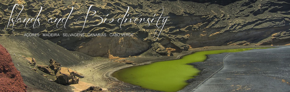
Lanzarote stretches over 862 km2 (not counting the islets that make up the archipelago of Chinijo) and is the fourth largest Canary Island. It is one of three islands in the province of Las Palmas de Gran Canaria and the second closest to Africa (after Fuerteventura) in all Macaronesia. At 670 m asl, the crags of Chache—part of Famara massif in the north—are the highest part of the island. Famara massif boasts two more high points, Corona volcano (609 m) and Risco de las Nieves (608 m), while in the south, Los Ajaches massif features Femés at 608 m and the peak of Hacha Grande at 560 m. The rest of the island is mostly flat, except for several volcanoes located in Timanfaya National Park and in La Geria, some of which exceed 500 m asl, and various barrancos, including Tenegüime ravine. Volcanic eruptions in 1730, 1736 and 1824 produced vast areas of historical lava flows that make up most of the national park and surrounding area. Particularly striking are the geomorphological features of the landscape, including extensive sand dunes or jable pumice in Famara and in other areas along the north and east coasts, and the beaches of organogenous sands at Famara, Matagorda and Papagayo. Another interesting feature of the landscape are the traditional salt flats at Janubio and Los Agujeros (Los Cocoteros), still worked today, while others at El Río and Arrecife are no longer in operation.
The climate is very similar to that of Fuerteventura, with average annual rainfall below 250 mm in practically all the island, except for the heights of Famara, whose altitude and gradient favour cloud formation in the area. The rainy season mainly falls between November and March, similar to the rest of the archipelago, with November, December and January being the rainiest months. Rainfall can occasionally be torrential, causing floods and damage to infrastructure and housing. The average annual temperature is around 20.8º C, January being the coolest month (16.4º C) and August the hottest (24.9º C). Winds blow for most of the year at an average speed of 24 km/h. Evidently, relative humidity is greater in the highest areas of the island, particularly in the heights of Famara and Los Ajaches. Proximity to the Sahara means that dust-laden clouds (the African harmattan wind) frequently engulf the island with hot dry air, drastically reducing visibility.
According to the 2009 census, Lanzarote is home to 141,938 people, spread over a total of seven municipal districts, the most populated being Arrecife (the island capital), Teguise, Tías and San Bartolomé. The most important tourist centres are Puerto del Carmen (Tías), Playa Blanca (Yaiza) and Costa Teguise (Teguise). In just over four decades, tourist accommodation capacity has mushroomed: from 171 places in 1965 to 63,421 in 2009.
Lanzarote is one of the most important tourist destinations in the European Union and the economy is mostly based on tourism and the services sector. Contributing factors are quality hotel accommodation and a range of tourist attractions, such as Los Jameos del Agua, Cueva de Los Verdes, Fundación César Manrique, Jardín de Cactus garden and the island network of vantage points, set against the backdrop of a uniquely beautiful landscape, declared a Biosphere Reserve by UNESCO. Despite the predominance of tourism, agriculture is still an important sector, particularly in areas like La Geria (vines), Teguise (sweet potatoes and tomatoes) and Haría (cereals, potatoes, pulses and vines). That said, the amount of cultivated land has dwindled since the 1970s, down from 12,713 hectares to just 4,734 in 2004. Conversely, both livestock and poultry farming are thriving, particularly sheep, goats, pigs and hens. Finally, fishing was always an important sector in Lanzarote, which is evidenced by the number of salt-works (especially in Arrecife) associated with the salted fish industry. The loss of the Canary Islands-Sahara fishing grounds in the 1970s sounded the death knell for this traditional activity, which has yet to recover.