Fuerteventura
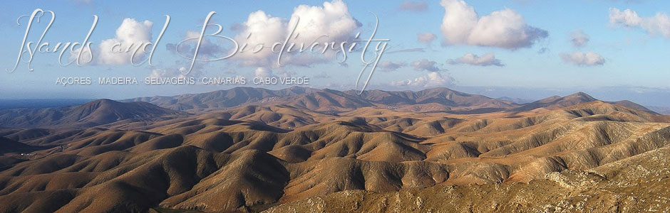
Fuerteventura (1,725 km2) is the second largest of the Canaries and one of the archipelago’s two easternmost islands. In all Macaronesia, it is the closest to continental Africa, lying just 96 km from Cape Juby, in Tarfaya, in south Morocco. The highest point is Pico de La Zarza (870 m), in Jandía massif, in the south of the island. Other significant high points are located in Betancuria massif (central area) and include Morro de la Cruz (676 m) and Morro de Gramán (659 m); further south, Montaña Cardón (691 m); and to the north, Montaña El Aceitunal (686 m) and Montaña La Muda (689 m). However, the island is mostly flat, with broad stony plains that extend over the central and southern sectors, alongside several jables or areas of organogenous sands, such as Corralejo and Lajares in the north, Vigochos or Biocho on the west coast and Matas Blancas or Jandía in the south. The highest cliffs lie on the east coast at Punta de La Entallada (rising to over 250 m at certain spots) and just south of Pozo Negro (100 m). On the west coast the cliffs between Jable de Vigocho and Terife beach (inside the military zone at Pájara) are also roughly 100 m high. By sharp contrast, a large part of the east coast, all the north shore and broad sectors of the south and west boast sandy beaches, low-lying areas and stretches of shingle. The longest beaches of fine golden sands are located in Jandía—Sotavento and Barlovento, measuring 6 and 8 km long, respectively. Inland, striking volcanic ridges and headlands heavily eroded over many millennia stand alongside several alignments of recent volcanic cones and vast extensions of malpaíses or badlands in the north (between Corralejo and El Cotillo and La Oliva-Lajares) and in the central eastern sector (Malpaís Grande and Malpaís Chico). Finally, the deepest ravines include La Herradura, to the north of Puerto del Rosario, Los Molinos and Vega de Río Palmas-Ajuy, on the western side of the island, La Torre, in the east, as well as a series of open ravines or valleys in Jandía massif, including Mal Nombre, Vinamar, El Ciervo and Gran Valle, and in the east, Jacomar.
The climate of Fuerteventura, far more arid than that of the central and western islands of the archipelago, derives from its proximity to northwest Africa and its low elevation (under 1,000 m), far below the band of clouds associated with the northeast trade winds. Average annual rainfall does not exceed 250 mm and there are far more sunny days throughout the year than in the rest of the archipelago, except for Lanzarote. In contrast, temperatures in winter and spring are relatively low (especially at night), due to the cool northerly winds. At certain times of the year, the dry dust-laden harmattan wind blows in, occasionally bringing plagues of African locusts. In short, the climate of the island has been described as warm, semi-arid and summery in practically all areas, although others are considerably damper, such as the heights of Betancuria and Jandía massifs, where the relative abundance of lichens on the north-facing escarpments and regular mist formation indicate significant atmospheric moisture.
Fuerteventura has a population of 106,450 inhabitants (2012 census) spread over six municipalities, but mainly located in Puerto del Rosario (the capital), La Oliva, Pájara and Tuineje. The most important tourist areas are Corralejo, in the north, Costa Calma and Morro Jable, in the south, and Caleta de Fustes on the eastern seaboard, which has sustained considerable growth in recent decades. The population has more than doubled in the last twenty years since the 1991 census that recorded 49,653 inhabitants.
Fuerteventura is one of the top destinations for European tourism, hence the economy is based on tourism and the service sector even more so than the other Canary Islands. The average tourist is a sun-seeker, which is not surprising given the miles of golden sands and hours of sunlight. However, rural tourism is a growing sector in inland areas, where trekking is also gaining adepts. The Cabildo island council is clearing and extending several trails and has also created a network of museums and themed visitors’ centres. In conclusion, diversification is high on the agenda. Traditional activities (agriculture, fishing and livestock farming, and small-scale artisanal industries) have dwindled appreciably, agriculture in particular, but livestock is still kept. Goats are the majority and are often left to roam free. Traditional apañadas or round-ups take place regularly, whereby the animals are herded into gambuesas or corrals—a practice that dates back to pre-Hispanic times. The fishing industry has its base in the ports or small harbours of Puerto del Rosario, Corralejo, El Cotillo, Gran Tarajal and Morro Jable. Additionally, the cultivation of aloe has blossomed in recent years and is providing a fine alternative to traditional agriculture.